Chaeseokgang Cliff (Jeonbuk National Geopark) (채석강 (전북 서해안권 국가지질공원))
2025-10-23
1, Byeonsanhaebyeon-ro, Byeonsan-myeon, Buan-gun, Jeonbuk-do
+82-63-582-7808
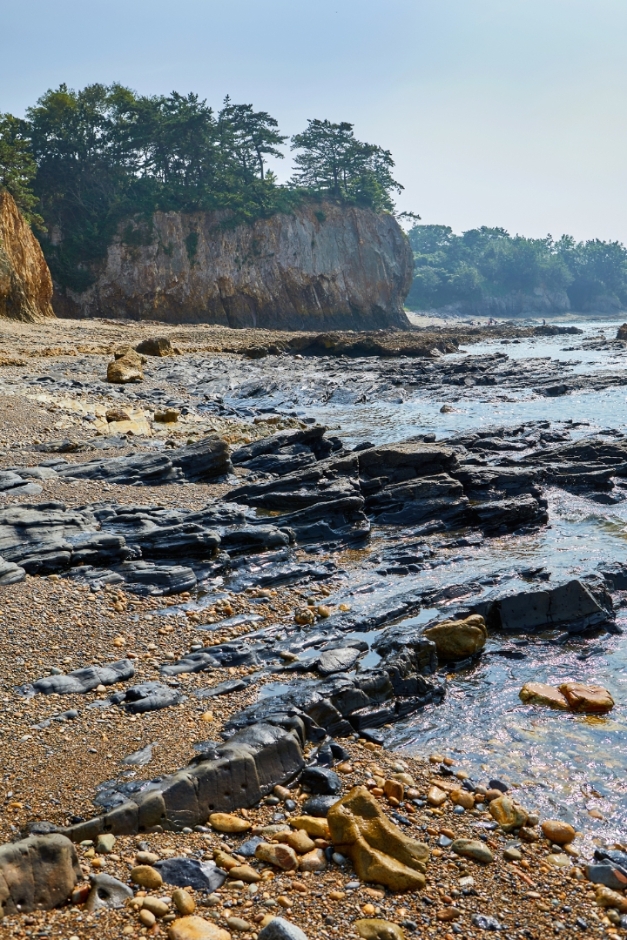
Chaeseokgang Cliff refers to a rocky cliff and the sea around it near the Gyeokpohang Port and Dagibong areas on Byeonsanbando Peninsula. The name Chaeseokgang was adapted as it resembles an attraction of the same name in China. Chaeseokgang Cliff was formed from many layers of rocks stratified by the sea, and the blue sea and the rock cliffs together create quite a lovely picture. It is nature’s masterpiece of stratification, and visitors can observe interesting structures and shapes that cannot be seen elsewhere.
Hongdo Island (홍도)
2024-03-08
9-8, Hongdo 1-gil, Sinan-gun, Jeollanam-do
+82-61-240-4051
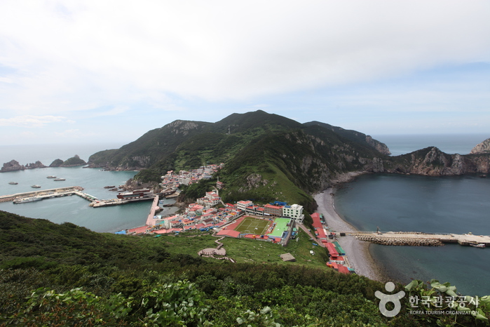
Hongdo Island is a picturesque island located about a 2-hour and 30-minute ferry ride from Mokpo Harbor. The island earned its name due to its striking red appearance during sunset. It boasts stunning rock formations, coastal cliffs, and clear blue seas, creating a beautiful natural landscape. Designated as a protected area with rare plants and animals, it is recognized as a natural monument. One of the best ways to experience Hongdo Island is by taking a sightseeing boat tour to explore its surrounding 33 rocky islets and cliffs.
Heuksando Island (흑산도)
2020-03-27
11, Jinmaeul-gil, Sinan-gun, Jeollanam-do
+82-61-275-9300
Heuksando Island is located at the southern end of Korea about 92.7 km away from Mokpo. It is composed of 11 uninhabited islands and 89 inhabited islands. Because of its natural beauty, it has been designated as part of Dadohae National Marine Park along with the nearby islands.
Heuksando Island has a circular road that can take you all the way around the island along the seashore. Following this road, you can see almost all of the beautiful natural and cultural treasures of the island. The Choryeongmok Tree, once designated as Natural Monument, is said to have the ability to conjur up spirits when its branch is broken and placed on a Buddhist altar. Nearby are Sangroksurim and Seonghwangdang. Also on Heuksando Island are designated Cultural Treasures such as the Jiseokmyogun, Samcheungseokdeung, Samcheungseoktap, and Banwolseong. Heuksan Mountain on the island has eight especially beautiful sceneries, which are called Heuksan Mountain Eight Sceneries. Among them, Munamchangsong, Songjeonmangwol, and Myeongsasipri are especially famous. Munamchangsong refers to evergreen trees covering the sky of Munamsan Mountain, and Songjeonmangwol refers to watching the moon in front of an evergreen at harvest full moon. Myeongsasipri refers to a large white sandy beach spread out in front of Jinri Village. The Eight Sceneries of Heuksan Mountain are must-see places for those who visit the island of Heuksando.
Gapsa Temple (갑사)
2021-12-17
567-3, Gapsa-ro, Gongju-si, Chungcheongnam-do
+82-41-857-8981
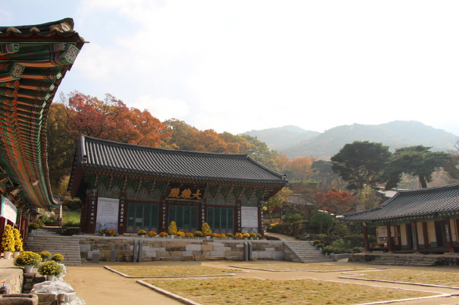
Gapsa Temple is located in the forested foothills of Gyeryongsan Mountain, 19 kilometers from Gongju and a three-hour walk from Donghaksa Temple. The temple is most beautiful during fall when surrounded by crimson foliage. Gapsa Temple was established by monk Adohwasang in 420, during the early Baekje Period. The temple's beauty allowed it to escape destruction many times, but it was ultimately burned down during the Imjin War (1592-1598). The current structures were built in 1604. Nearby attractions include Yongmunpokpo Falls, Sujeongbong Peak, and Cheonjinbotab Pagoda.

Gyeryongsan National Park (계룡산국립공원)
2026-02-02
327-6 Donghaksa 1-ro, Banpo-myeon, Gongju-si, Chungcheongnam-do
+82-42-825-3002
Gyeryongsan National Park stretches across the cities of Daejeon, Gongju, and Nonsan in Chungcheongnam-do and was made a national park on December 31, 1968. The name of the mountain comes from the fact that the ridgeline looks like a dragon wearing a chicken's crest on its head. The topographical features are what make this mountain stand out and its mysterious folklore is what makes it so interesting. The park features many peaks, including the main peak Cheonhwangbong (alt. 847 m), as well as Sambulbong, Yeoncheonbong, and Gwaneumbong Peaks. This mountain is famous for its many interesting sites, with its fantastic rock structures, attracting hikers from across the country.
![Gongju Gongsanseong Fortress [UNESCO World Heritage] (공주 공산성 [유네스코 세계문화유산])](https://tong.visitkorea.or.kr/cms/resource/75/2678675_image2_1.jpg)
Gongju Gongsanseong Fortress [UNESCO World Heritage] (공주 공산성 [유네스코 세계문화유산])
2026-02-02
280 Ungjin-ro, Gongju-si, Chungcheongnam-do
+82-41-856-7700
Gongsanseong Fortress is a fortification situated at the heart of Gongju, which served as the capital of the ancient Baekje kingdom (18 BCE - 660 CE) from 475 to 538. Even after Baekje's fall, subsequent dynasties such as Silla (57 BCE - 935 CE), Goryeo (918-1392), and Joseon (1392-1897) continued to use Gongju as a regional administrative center. As a result, numerous historical sites have accumulated in the area over time. From the fortress, visitors can enjoy a panoramic view of Gongju's city center and the Geumgang River.
Eight Scenic Views of Danyang (단양 팔경)
2020-08-19
Danseong-myeon, Danyang-gun, Chungcheongbuk-do
+82-43-422-1146
The Eight Scenic Views of Danyang are known as the most beautiful places in Danyang, and include Dodamsambong Peaks and Seongmun Natural Arch by the Namhangang River, Gudambong Peak and Oksunbong Peak offering outstanding views of Chungjuho Lake, Sangseonam Rock, Jungseonam Rock, and Haseonam Rock in Seonamgyegok Valley, and Sainam Rock in Unseongugok Valley. Theses areas were visited many times by numerous scholars during the Joseon dynasty and contain many historically and culturally important relics.

Piagolgyegok Valley (피아골계곡)
2024-02-02
Piagol-ro, Gurye-gun, Jeollanam-do
+82-61-780-7700
Piagolgyegok Valley is located in Jirisan Mountain between Nogodan and Banyabong Peaks. The name of the valley comes from the crimson red maple leaves that fill the valley in fall. It is also one of the ten most beautiful highlights of Jirisan Mountain. The valley is famous for its fall colors, but it is also a beautiful place to visit all year around, from azaleas in spring to snow-covered rocks in winter.
Near the entrance to Piagolgyegok Valley is the largest temple in Jirisan Mountain, Yeongoksa Temple, and national treasures. The valley is not steep, providing an easy walk for all visitors. The trail stretches 6 kilometers from the ticket booth, and passes many beautiful places like Yeonjudam and Samhongso Pond. At the end of the valley, the trail continues another 2 kilometers up a steep hillside to reach Imgeollyeong Pass.
Gosudonggul Cave (단양 고수동굴)
2024-10-08
8 Gosudonggul-gil, Danyang-eup, Danyang-gun, Chungcheongbuk-do
+82-43-422-3072
Gosudonggul Cave, a natural limestone marvel, is recognized as a Natural Monument of Korea. Spanning nearly 1,700 meters in length, this ancient cave has been shaped over 500 million years. Inside, visitors can marvel at an array of spectacular formations including stalactites, stalagmites, underground lakes, and cave pearls. The cave also houses unique rock formations such as Sajabawi Rock, Dodamsambongbawi Rock, a statue resembling the Virgin Mary, and the romantically named Thousand-year Love Rock. The cave is conveniently located just one kilometer from the Danyang Intercity Bus Terminal.
Magoksa Temple [UNESCO World Heritage] (마곡사 [유네스코 세계문화유산])
2026-01-29
966 Magoksa-ro, Sagok-myeon, Gongju-si, Chungcheongnam-do
+82-41-841-6220
Situated at the foot of Taehwasan Mountain in Gongju, Magoksa Temple was established in 640 during the reign of Queen Seondeok of the Silla dynasty. It was originally founded as a grand temple, but only few major halls and gates remain preserved today along with several significant cultural relics and heritages. The temple site was used as a refuge site during times of war, and it survived the the Imjin War (1592-1598) and the Korean War (1950-1953).
 English
 한국어
한국어 日本語
日本語 中文(简体)
 Deutsch
 Français
 Español
 Русский