
Cheongchoho Lake (청초호)
2026-02-03
140 Expo-ro, Sokcho-si, Gangwon-do
+82-33-639-2690
Located in the heart of Sokcho, Cheongchoho Lake is a vast natural lagoon with a 5-kilometer circumference. Fed by the Misiryeong Valley of the Taebaeksan Mountain Range via Cheongchocheon Stream, the lake acts as a scenic bridge between the river and the East Sea. At its center sits Cheongchojeong Pavilion; reached by a 75-meter bridge, it offers panoramic views of Seoraksan Mountain and is celebrated as Sokcho’s finest night-view spot. The lakeside is adorned with dragon sculptures from local legend and features illuminated trails perfect for an evening stroll. Visitors can also explore the nearby Seok Bong Ceramic Museum of Art, a bird sanctuary, and the 73.4-meter Expo Tower, a landmark from the 1999 Gangwon International Travel Expo.
Gangchon Resort (강촌유원지)
2021-04-27
The area of Namsan-myeon, Chuncheon-si, Gangwon-do
+82-33-250-3896
The Gangchon Resort, as one of Chuncheon’s major resorts, stretches along the Bukhangang River and the Gangchoncheon Stream. It offers splendid scenery and many neighboring tourist attractions, such as Gugok Falls, Deungseon Falls, and Samaksan Mountain. It has excellent accessibility of public transportation, many theme park facilities, and accommodation facilities, so it has been a popular location for a young people’s membership trip from the 1970s to the 1990s. However, along with the opening of the double-track railway on the Gyeongchun Line in 2010, the Gangchon Station building was relocated and consequently, the number of visitors has decreased and the local business experienced depression. Therefore, there has been a campaign to revitalize Gangchon. Near the former Gangchon Station, the large sculpture “Ddo-ori Gangchon” has been installed, and the reduced-size model of the Deungseongyo Bridge (suspension bridge), which was a famous tourist attraction in the past, has been reproduced. In particular, “Ddo-ori Gangchon,” which is a popular photo zone, was built by embodying the Scaly-side Merganser (Mergus squamatus, Natural Monument No. 448), which come the area of Gangchon in winter. Additionally, the Deungseongyo Bridge, which was Korea’s first suspension bridge, but demolished in 1985, was reproduced as a tourist pedestrian bridge with a length of 58 m. Furthermore, Gangchon Land, which is a well-known theme park, and the activity of four-wheel motorcycle riding along the riverside, are also major tourist attractions in Gangchon.
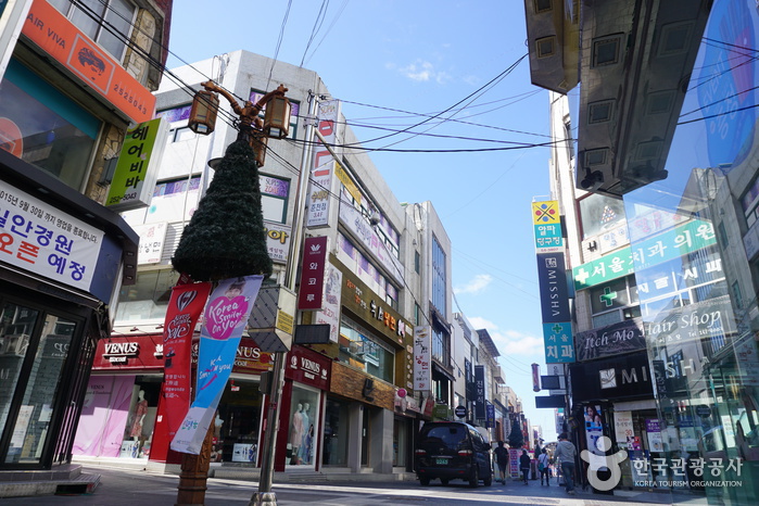
Chuncheon Myeongdong Street (춘천명동거리)
2024-02-28
Jungang-ro 1-ga, Chuncheon-si, Gangwon-do
+82-33-250-3089
The street, named after Seoul's Myeong-dong, has become the main thoroughfare in Chuncheon. Although it is not particularly large, it links to the Yungnimgogae Pass and serves as a vibrant hub for youth, hosting a variety of shops and shopping malls that draw crowds. Additionally, the street is home to theaters, cafés, government buildings, major banks, and an underground shopping center. It also provides access to other popular tourist destinations in Chuncheon, including Myeongdong Dakgalbi Alley and Jungang Market.

Chuncheon Myeongdong Dakgalbi Street (춘천 명동 닭갈비 골목)
2026-02-11
52 Joyang-dong, Chuncheon-si, Gangwon-do
+82-33-250-3089
This alley is lined with dakgalbi (spicy stir-fried chicken) restaurants in Myeong-dong, which is Chuncheon's main street. Chuncheon-style dakgalbi originates from the story in which people marinated chicken instead of pork and grilled it with charcoal like pork ribs in the 1960s. Later, various vegetables, such as cabbage and onion, were added to the dish and stir-fried together on an iron plate. As people can eat it plenty at a reasonable price, dakgalbi has been popular among college students and soldiers, and at this time, dakgalbi earned its nicknames such as “People’s galbi (ribs)”, and “College students’ galbi.” The Dakgalbi Alley was established as dakgalbi restaurants were opened one by one on the backstreet of Myeong-dong in Chuncheon, in the 1970s to 1980s. Currently, this 150-meter-long alley is packed with dakgalbi restaurants on both sides. Along with charcoal-grilled spicy chicken and spicy griddled chicken, customers can try Chuncheon buckwheat noodles, which are also a famous local delicacy. The information panel explaining the history of Chuncheon spicy stir-fried chicken is installed in the alley. This alley is also known for the filming location for the Korean TV entertainment program Infinite Challenge and other programs.
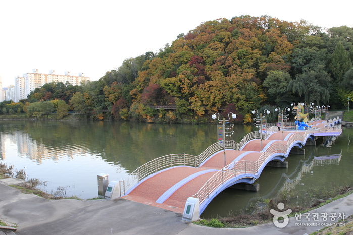
Gongjicheon Stream (Gold Scales Theme Street) (공지천(황금비늘테마거리))
2022-12-26
25, Ethiopia-gil, Chuncheon-si, Gangwon-do
+82-33-250-3322
The city of Chuncheon is surrounded by Uiamho, Chuncheonho, and Soyangho Lakes and is widely known as "Lake City." Much like the Hangang Riverside Parks are a representative landmark of Seoul, Gongjicheon Resort beside the stream is a treasure of Chuncheon. The resort is complete with a sculpture park, fountain, boat dock, outdoor stage, playground and more.
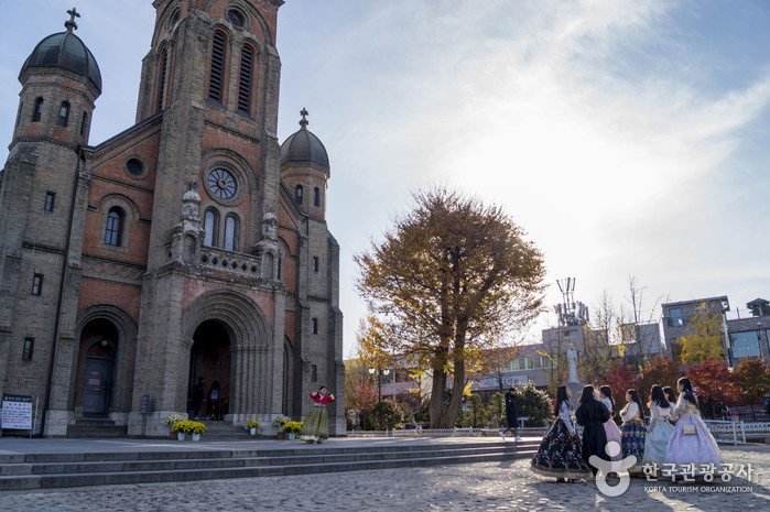
Jeonju Jeondong Catholic Cathedral (전주전동성당)
2024-05-27
51 Taejo-ro, Wansan-gu, Jeonju-si, Jeonbuk-do
Jeondong Catholic Cathedral in Jeonju was built in honor of Roman Catholic martyrs of the Joseon dynasty on the very same spot the martyrs lost their lives. The land was purchased by French Priest Baudenet in 1891 (28th year of King Gojong), but construction of the church did not begin until 1908. Construction was completed in 1914, a time during which Korea was under Japanese rule. Though originally built just outside of Pungnammun Gate, the site of the martyrs, the church was later moved to its current location for expansion.
The first Romanesque building in the Honam region, Jeondong Catholic Cathedral is made of gray and red bricks and bears a striking resemblance to the Myeongdong Cathedral in Seoul, also designed by Priest Poinel. Not only considered one of the most beautiful Catholic churches in Korea, some even go so far as to say it is one of the most beautiful structures in all of Korea, citing the church’s unique combination of Byzantine and Romanesque architectural styles. The rectangular building is topped with three Byzantine bell towers (to the right, center, and left) and boasts arched ceilings, several of which meet in the form of a cross.
It is interesting to note that some of the bricks used in construction of the church were made using materials from the Jeonjueupseong Walled Town, which was torn down by the Japanese. It is also said that the cornerstone of the church came from a wall of Jeonjueupseong Walled Town near Pungnammun Gate.

Abai Village (아바이 마을)
2026-02-03
122-1 Cheongho-ro, Sokcho-si, Gangwon-do
Located in Cheongho-dong, Abai Village bears a history of displaced people’s distress. The village was formed by refugees of the Korean War from North Korea, mainly from Hamgyeong-do Province. The word “abai” is a dialect of Hamgyeong-do that means a friendly old man like a grandfather. Visitors to Abai Village can get a sense of displaced people’s life and story, which fade away into a chapter of history. Although it has lost its original appearance now, old shacks without a gate still remain here and there. Mural paintings on the wall show the sentiment of nostalgia about their hometown and express sorrow and hard life of displaced people, who lived from hand to mouth by fishing and doing physical labor. The original houses built by refugees in the village were restored into the Refugee Village at the Sokcho Museum. Abai Village is also known as a filming location for the Korean TV drama "Autumn in My Heart," attracting a lot of visitors and becoming a major attraction in Sokcho. The restaurant alley is packed with cafes and North Korean food restaurants serving local dishes such as Hamheung-style cold buckwheat noodles, stuffed squid, and North Korean-style sausage soup.
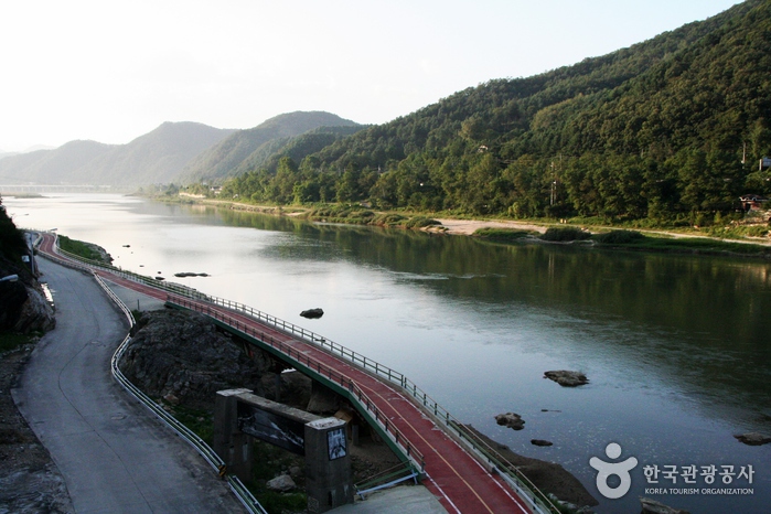
Yeongnangho Lake (영랑호)
2022-12-21
140, Yeongnanghoban-gil, Sokcho-si, Gangwon-do
+82-33-639-2690
Yeongnangho Lake is a deep and large lake with a circumference of 7.8 km, an area of about 1.2 km2, and a depth of over 8 m, formed by the development of coastal dunes. The source water originates from the Jangcheoncheon Stream, passing through the lake, and goes to the East Sea via the waterway under the Yeongnanggyo Bridge. The lake is adjacent to the areas of Jangsa-dong, Yeongnang-dong, Dongmyeong-dong, and Geumho-dong. The pleasant trail is also established around the lakeside, surrounded by the beautiful scenery of cherry blossoms, azaleas, and reeds. According to Samguk yusa (Memorabilia of the Three Kingdoms), the name of the lake comes from Silla’s hwarang (elite warrior group in Silla) member named “Yeongnang.” After training at Geumgangsan Mountain, Yeongnang passed this lake on the way to get to the martial arts competition. As he was so taken by the splendid landscape, however, he forgot about the competition and stayed here for a long time. As the old record says, Yeongnangho Lake boasts outstanding scenery. Beombawi Rock, in particular, evokes visitors’ admiration as one of the Eight Sights of Sokcho. The rock, which resembles the shape of a tiger crouching down, has an aura of mystery. The nearby tourist attractions also include Gwaneumam Rock, which is known for the strange rocks and bizarre stones, Bogwangsa Temple, and the Wetland Eco Park, which is located in the west of the lakeside.
Deokjin Park (덕진공원)
2024-04-07
390, Gwonsamdeuk-ro, Deokjin-gu, Jeonju-si, Jeonbuk-do
+82-63-239-2607
Deokjin Park is a representative city park of Jeonju. Officially designated a city park in April 1978, it is centered around a natural pond, which dates back to the Goryeo dynasty (918-1392). The park is such a landmark of the area that the lotus flowers blooming in the park’s large pond are considered one of the most impressive attractions of Jeonju. The park spans an area of 13,000 ㎡ with the pond covering about two thirds of the southern sector. An arch-shaped suspension bridge stretches across the middle of the pond, offering up-close views of the lotus blossoms.
Park designers created a traditional pavilion and a water iris garden in honor of the park’s historical background and added an artificial waterfall and wooden bridge for visual effect. The park also houses nine stone monuments including the Children’s Charter, engravings of Shin Seok-jeong and Kim Hae-gang’s poetry, and a statue of General Jeon Bong-jun.
The park is the site of the annual Dano Changpomul (Water Iris) Festival, a much-anticipated event held on the day of Dano (a Korean traditional holiday that falls on the fifth day of the fifth lunar month). During the celebration, women wash their hair in iris-infused water from the pond to wish for good health in the coming year.
Jeonjuhyanggyo Local Confucian School (전주향교)
2025-07-22
139 Hyanggyo-gil, Wansan-gu, Jeonju-si, Jeonbuk-do
Jeonjuhyanggyo is a local Confucian school that was established during the Joseon dynasty (1392-1910) and is a designated Historic Treasure. This was a national education center during the Joseon period. The school was originally located at the Gyeonggijeon Shrine site, but was relocated in 1603. The mortuary tablets of seven Chinese Confucian scholars and 18 Korean scholars are enshrined in the main building of Daeseongjeon Hall. The site is popular for its 400-year-old ginkgo tree in the front yard, and is the most beautiful in fall.
 English
 한국어
한국어 日本語
日本語 中文(简体)
 Deutsch
 Français
 Español
 Русский