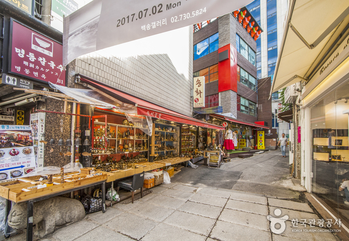
Insa-dong Antique Art Street (인사동 고미술거리)
2024-12-30
29 Insadong-gil, Jongno-gu, Seoul
+82-2-732-2235
As of today, there are approximately 70 shops in the Insa-dong area that sell antique arts. Some of the products they sell include antique artworks, porcelains, woodcrafts, and metalwork. Visitors may even find rare and valuable products such as earthenware from the Silla period or white porcelain used in the Joseon dynasty. Each shop is a specialty store, authorized to sell product types that are of their expertise, ranging from antique furniture and traditional artworks to handcrafted items.
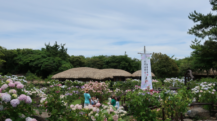
Jeju Folk Village (제주민속촌)
2024-11-14
631-34 Minsokhaean-ro, Pyoseon-myeon, Seogwipo-si, Jeju-do
Jeju Folk Village reproduces the old life of Jeju in the 19th century. More than 100 traditional Jeju houses and folk culture are being recreated and exhibited through archival research. The village is planted with local trees and flowers from Jeju and Korea, so visitors can enjoy flowers in all seasons. It features themed exhibition halls, model houses, and traditional folk games, attracting numerous visitors.
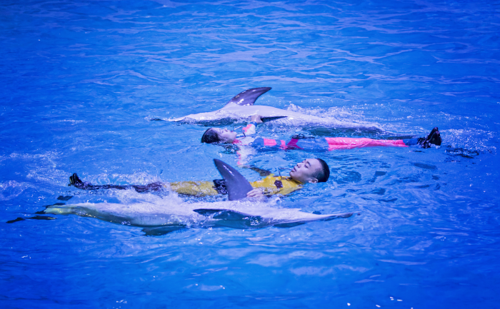
Pacific Land (퍼시픽랜드)
2020-04-24
154-17, Jungmungwangwang-ro, Seogwipo-si, Jeju-do
+82-1544-2988
Pacific Land, located within the complex of Jungmun Resort, offers performances, exciting experiences, and a grand buffet for a full day of fun. It is also along Olle-gil Course 8, making it a popular stopping point for visitors. The Marine Stage has four performances daily, featuring monkeys, dolphins, and seals. Guests looking for a romantic experience will enjoy the yacht tour. The Viva Jetboat is popular among active visitors. The El Marino Buffet takes place on a yacht for a truly unique experience.

Yeoju Silleuksa Temple (신륵사(여주))
2025-06-30
73 Silleuksa-gil, Yeoju-si, Gyeonggi-do
Silleuksa Temple is located along the upper section of the Namhangang River as it flows from Bongmisan Mountain in Yeoju. It is believed that Silleuksa Temple was built by Monk Wonhyo during the reign of Silla King Jinpyeong, but there is no evidence to prove this. The temple is famous for being a place where Naong Hyegeun stopped in 1376. The temple began to be called Boeunsa in 1472, but the name changed back to Silleuksa Temple in 1858.
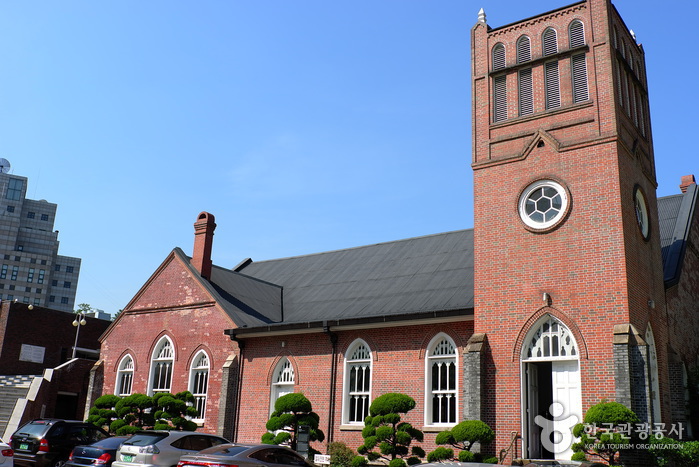
Chungdong First Methodist Church (서울 정동교회)
2020-06-25
46, Jeongdong-gil, Jung-gu, Seoul
+82-2-753-0001
Chungdong Church, having being completed in 1897, was the first Christian church that was built after the spread of Protestantism in Korea. The church was founded in 1887 as a small worship house under the name Bethel by Henry Gerhard Appenzeller, an American missionary. As the number of followers increased, the building underwent construction and officially became a church in 1895. Chungdong Church is the only remaining church building from the 19th century. The church was expanded once more in 1926, changing its from a cross-shaped building to a square one. The expansion was made by adding walls using bricks as not to damage the original building structure. The architecture was built in a simplified version of an American gothic house with arched window frames.
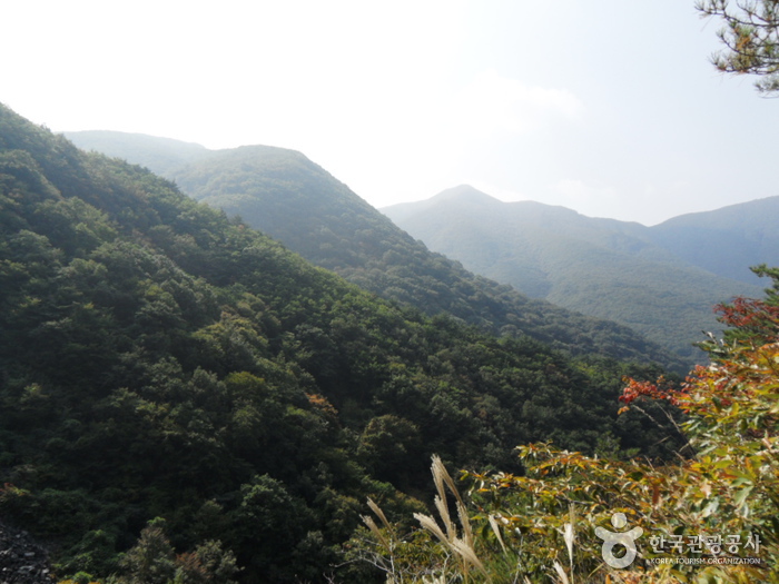
Gajisan Provincial Park (Miryang Section) (가지산도립공원(밀양))
2021-05-31
Sannae-myeon, Miryang-si, Gyeongsangnam-do
+82-55-359-5357
Situated 1,240 meters above sea level, Gajisan Mountain is famous for its beautiful stones and rocky peaks. There are a variety of things to see on the mountain besides the beautiful stones. In fall, the pampas grass provides a spectacular sight as the whole mountain peak is covered in autumn colors. The mountain attracts many hikers wanting to see oddly-shaped rocks like the famous Ssalbawi Rock.
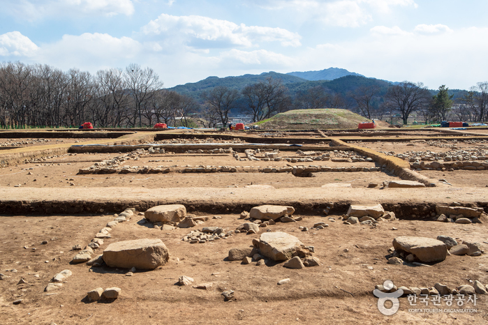
Gyeongju Wolseong Palace Site (Banwolseong Fortress) (경주 월성(반월성))
2023-01-03
Inwang-dong, Gyeongju-si, Gyeongsangbuk-do
+82-10-3226-6390
This was the location of the palace-fortress during the Silla dynasty (57 BC ~ AD 935). The fortress takes after its name, which, literally translates to mean a crescent moon shape on top of a hill. The famous history books of Samgukyusa mention that Silla’s 4th King Seoktalhae (AD 57~80) thought this area was an ideal spot for the fortress and bought the land from a nobleman. The 2nd King Namhae (AD 4~24) impressed by Seoktalhae’s actions, took him in as his son-in-law, later, becoming the 4th king. The area was then under Silla’s rule for 900 years, the last king being the 56th, Gyeongsoon (AD 927~935).
Although the magnificent grandeur of the palace is now just an empty lot, it has been told that this area was filled with imperial buildings during the Silla dynasty. Currently, the region of Wolseong has a freezer made out of rocks called Seokbinggo, an archery range, a horse-riding field, and a traditional playground, which resembles the grounds of the Joseon Period (the dynasty that ruled the Korean peninsula from 1392-1910).
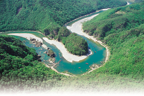
Eorayeon Valley -Gangwon Paleozoic Geopark (어라연-강원고생대 국가지질공원)
2022-12-29
259 , Eorayeon-gil, Yeongwol-gun, Gangwon-do
+82-33-372-1705
A beautiful and mysterious valley located 12 km up the Donggang River, Eorayeon Valley is renowned for its clean waters and for the many fish that inhabit it. The valley has beautiful rock formations and a dense pine forest that were designated as the National Scenic Spot in December 2004. It is one of Korea's most popular sites for rafting, followed by Naerincheon Creek and Cheorwon's Hantangang River. The trail to Eorayeon through Jatbong Peak is also quite popular (approx. 3 hours).

Amnam-Park (암남공원)
2025-07-18
Die großartigen Aussichten auf die prächtigen Klippen und die mit Bäumen gesäumte Küste vom Amnam-Park lassen das blau-grüne Wasser mit der bewaldeten Landschaft verschmelzen.
Nach der Erklärung zum Schutzgebiet war der Zutritt zu diesem Gebiet verboten, bis es schließlich 1996 wieder der Öffentlichkeit zugänglich gemacht wurde, und Besucher zum ersten Mal die unberührte Landschaft erleben konnten.
Im Park kann man heute angeln, ein Observatorium besuchen und sich an Spazierwegen und einer erhabenen Brücke erfreuen. Die Fülle an Pinien entlang der Wege machen es zu einem angenehmen Spaziergang; auf dem Weg hinauf zum Observatorium bietet dieses gut beforstete Gebiet großartige Aussichten. Wenn Sie angeln möchten, können Sie dies auf dem Meer oder von den fantastisch geformten Felsen aus tun.
Es gibt eine berühmte Straße vom Songdo-Strand zum Amnam-Park, die beliebt ist für sehr gemütliche Fahrten. Die Fahrt dauert etwa 5 min., wenn Sie zu Fuß gehen wollen, brauchen Sie etwa 20 Minuten.
Cheongpyeong Lake (청평호반)
2021-05-08
1906-15, Yumyeong-ro, Gapyeong-gun, Gyeonggi-do
+82-31-582-8830
Cheongpyeong Lake is an artificial lake that was formed with the construction of Cheongpyeong Dam in the Bukhangang River. Surrounding mountains and lake landscapes blend together harmoniously creating breathtaking views and is fast becoming a choice destination in Korea.
Near Cheongpyeong Lake there is an amusement park as well as numerous summer homes. On the nearby lake, one can enjoy water skiing and a host of other recreations. In addition, accommodation is also available making this destination a famous vacation spot all-year-round. Around Cheongpyeong Lake, there are a total of 30 boating areas for water skiing, motor boats, jet skis, banana boats, and various other water activities. All instrument rentals and lessons are also available.
 English
 한국어
한국어 日本語
日本語 中文(简体)
 Deutsch
 Français
 Español
 Русский